Are we there yet? One may well ask When the Todmorden panels are going to be completed. If I keep chipping away at the task, hopefully this summer visitors to the site will be able to interpret it when staff are not around, by reading a few facts and stories, and seeing some images of Todmorden's amazing history.
We've already been through a round of writing two summers ago, but the finished product needed refinement, and more accessible text and images. There are a lot of ways to approach this interpretive device, and presented here is one version - image heavy, much lighter text, more story oriented, and trying to illustrate an interpretive framework developed in the summer of 2010: People, Process, Place - the people, the industry and the ecology of Todmorden Mills.
If you see anything on the four panels that are posted here that you question for any reason, please comment. This is a public forum, and I hope I can workshop the approach here.
Monday, June 11, 2012
Sunday, June 10, 2012
Cross Valley Connectors
Todmorden’s roads and bridges were a vital transportation network for trade and travel across the Don Valley.
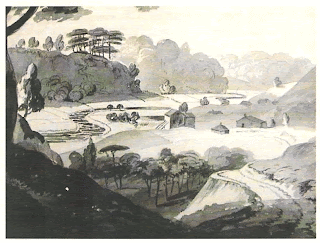
Before 1800, when the first mills were built at Todmorden, the volume and velocity of the Don River was much greater than it is today, and the river was the first transportation route through the valley. In summer, it was navigable by boat or canoe from the bay up to the flood plain south of Todmorden. In winter its frozen surface created an clear highway for horse-drawn sleighs carrying people and merchandise to and from farms and industries north of the city.
 |
| John Elliott Woolford "Mill Three Miles from York" 1819. Library and Archives Canada, Acc. No. 1979-9-29 |
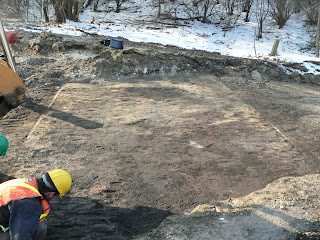
A rare paved road uncovered at Todmorden Mills
 |
| Photos Historic Horizon, Inc. |
 |
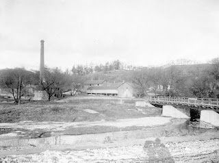
| Todmorden's bridge linked the two sections of the brick road. |
 |
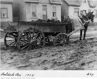
| Toronto, 1908 Toronto Archives Fonds 1244 William James |
Muddy road conditions plagued early Toronto travellers and merchants. "The roades are so bad they are killing our horses,” wrote brewery owner, William Helliwell in his journal in 1833.
Land grant recipients in Upper Canada, such as the settlers at Todmorden, were required to help in clearing land and improving roads, but paved, or "macadamized" roads were rare in the 1800s. Even into the 20th century many Toronto roads were rough unpaved wagon tracks, sometimes impassable in wet weather.
 |
| The Todmorden bridge crosses the Don River and connects the two sections of the brick road, 1931. |
Before construction of the Don Valley Parkway, the Don River flowed in a large
meander, or oxbow, under Todmorden’s bridge.
The bridge linked the two sections of the brick road, connecting Pottery Road to the Brick Works on the other side of the valley. The old brick road ran in a straight line from the bridge to the Brick
Works, passing under the railway trestle.
 |
 |
| Todmorden's bridge before the 1920s elevation of the embankment. |
Todmorden was
frequently threatened by destructive floods, and the embankments for the bridge
have been elevated several times to lift it above flood level. The bridge
piers, built in layers of different materials, record multiple efforts to
protect this crucial transportation link.The flagstone layer dates from 1920, while the piers at the base are one of earliest of examples of the use of poured concrete in Toronto.
Between 1847 and 1900, Todmorden’s mills closed, and their buildings were repurposed to provide housing for Brick Works employees and stables for horses. As the site was elevated with landfill to protect it from the flooding river, earlier structures, including the first storeys of the paper mill and the brewery, and their mill races, were filled in and buried.
Construction
of the Don Valley Parkway bisected Todmorden Mills. The Don River was channelized and moved to the western side of the expressway. Pottery Road, which once ran across the
valley and up the Cudmore Creek ravine, now ends at Bayview Avenue.
A 1955 aerial plan for the expressway construction shows the former paths of the
Don River oxbow, Pottery Road, Todmorden’s bridge and head mill race, and the road to the
Brickworks.
Subscribe to:
Posts (Atom)
